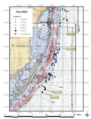
Notch continues to be tracked in the same area. Over the course of the past 6 days, he has been limited to an area that encompasses about 8 square miles. His location continues to vary in terms of distance offshore going as far as 12-15 miles at times. This area puts him in about 450-600 feet of water. I am posting 2 pictures for us to see prior to the weekend. Our traditional tracking map and then a more nautically oriented map showing points over the past couple of days. I am also enclosing NOAA's track of the Gulf Stream, that has been looked at every day to ensure that Notch continues to stay in the Gulf Stream for food.
COASTAL WATERS FORECAST FOR SOUTH FLORIDA
NATIONAL WEATHER SERVICE MIAMI FL
245 PM EDT FRI JUN 3 2005.
GULF STREAM HAZARDS...NONE.
THE APPROXIMATE LOCATION OF THE WEST WALL OF THE GULF STREAM AS OF JUN 03, 2005 AT 1200 UTC...2 NAUTICAL MILES EAST OF FOWEY ROCKS.
As we can see, Notch is well within the Gulf Stream based on his points and the tracking of the Gulf Stream which changes almost daily.

2 Comments:
What happened to the tracking of Naia?
Naia is assumed to be with Notch but is not mentioned since there is no tag on her. While this may sound as though we are unsure, it is common practice when referencing data collected to mention only the animal on which the tag was placed on. On a more comforting note, if something had happened to Naia, we would have received word as most animals tend to wash up on our coastline if they expire. Furthermore, since Notch's track has actually kept him reasonably close to shore(within 15 miles) over the past 4-5 weeks and our currents have onshore tendencies, we would have seen her. We have not received any such call or information.
Post a Comment
<< Home